
Updates and information, stories and history, amazing nature photography
By Andrew Harris, photos by Mel Hunt
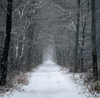
If you regularly enjoy any part, or all of the nine mile stretch that was the Wellsville-Addison-Galeton Railroad, now the WAG trail , then you get it. This is a unique piece of public land and we are looking forward to providing regular editions of “Walking the WAG”
If you haven’t visited this unique NY State public land between Wellsville and the Pennsylvania State borderline, put it on your list for 2025. Go to NYS WAG Trail site
This is the most popular walking trail in the wilds of Allegany County for several good reasons, here are my top three:
1- The WAG Trail is on the banks of the legendary Genesee River, one of the few rivers in North America that flows north. A nature lovers dream and depending on the time of year, it is hard to not find at least a marvel like a bald eagle, osprey, whitetail deer, river otters, ducks, geese, songbirds, cottontail rabbits, red fox, the list goes on and on.
2- Flat terrain invites all ages, abilities, and modes. Walkers, joggers, runners, mountain bikes, baby strollers, two legs, four legs, just NO ATV’s. Snowmobiles are allowed and some sections are groomed by the local snowmobile club. No other motorized vehicles are allowed on the trail.
3- Multiple points of access is another great part of the WAG trail. Many start in Wellsville at the famous trestle bridge at Island Park, walk through the ruins of the Sinclair Oil Refinery, and south toward “Gypsy Lane.” From that Wiedrich Road bridge south, the trail has many other places you can hop on and move either north or south. Most stops like Jack Bridge Road or Mapes Road have dedicated parking areas. Below are some of the access points south of Wellsville with map links:
- Carter Road parking area (42.075717°N, 77.927248°W) Google Maps
- Mapes Road parking area (42.046297°N, 77.926540°W) Google Maps
- Graves Road parking area (42.024614°N, 77.907379°W) Google Maps
- Hawks Road north parking area (42.016593°N, 77.893977°W) Google Maps
- Hawks Road south parking area (42.001079°N, 77.878507°W) Google Maps
This nine mile stretch of history is also full of ruins from the glory days of the railroad. From the trellis bridge at Island Park that is still serving pedestrian traffic to the recently rehabilitated bridge in Shongo NY you will find many remnants of a day gone by.
Be ready to hear much more about the WAG Trail from people that know the trail best. Photographer Mel Hunt has logged thousands of hours and miles on the trail and will be bringing her art and knowledge of the her favorite haunt. Naturalist, columnist, and Allegany County advocate Bob Confer will be chiming on the trail with his “Exploring the WNY Wilds,” column. NYS Department of Environmental Conservations officers and forest rangers will be using this new platform to keep the public educated on important issues that impact the WAG, as well as special interest topics. I have features on trash dumping, trail stewardship, wild foods, and giant hogweed in my pocket. Any local WAG Trail lovers are encourage to submit pictures, paintings, writing, and historical information, email anytime:
WellsvilleSun@yahoo.com
Tim Shea Plumbing and Heating are the sponsor of this first “Walking the WAG.” Are your customers reading this new feature? Get in touch soon if you’d like to find out how to be the next sponsor!!